

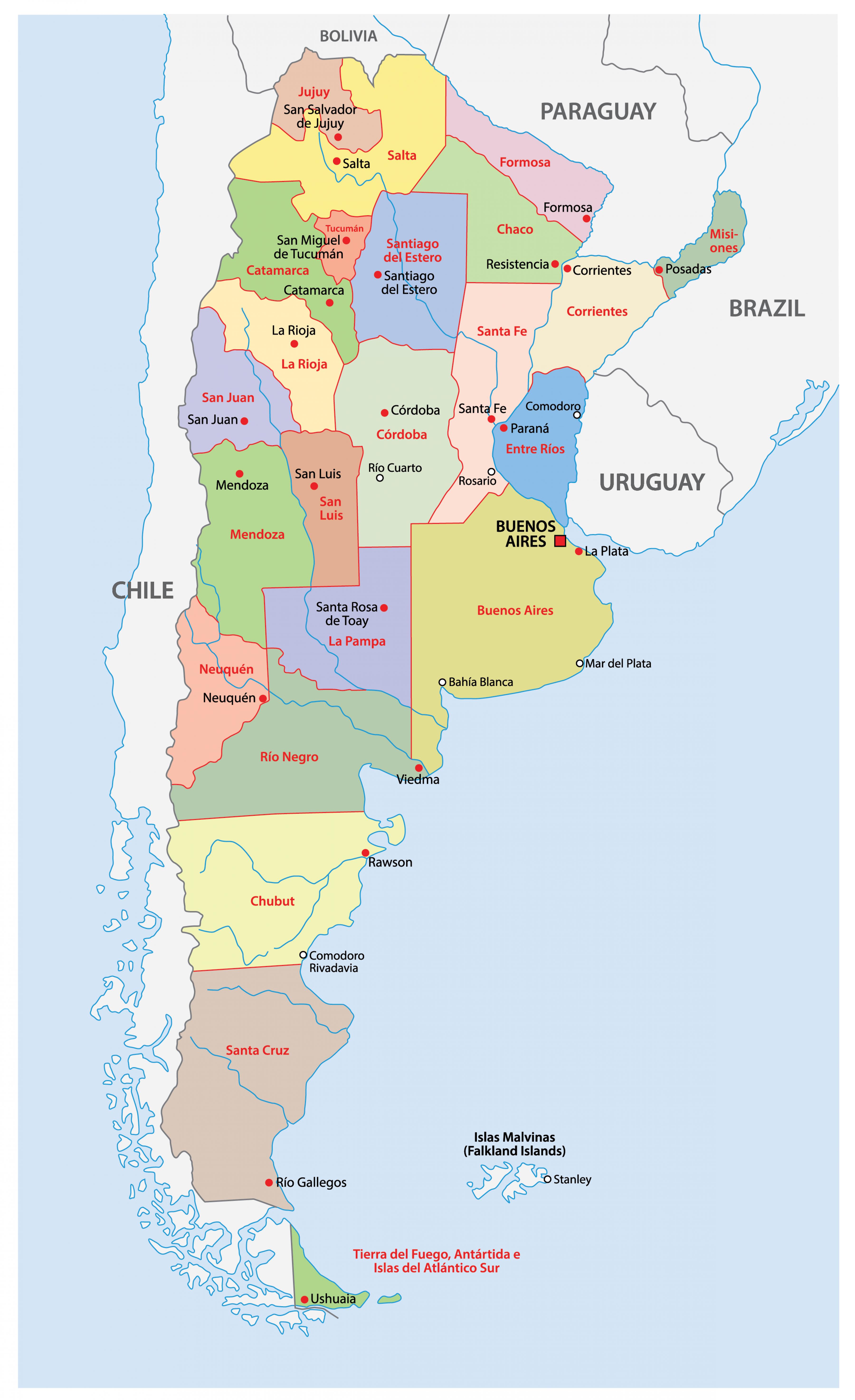
You can find on this page the Argentina region map to print and to download in PDF. The Argentina political map presents states, regions, provinces and surrounding areas of Argentina in South America.

The Argentina regions map shows surrounding areas and provinces of Argentina. This administrative map of Argentina will allow you to know regions of Argentina in South America. The Argentina regions map is downloadable in PDF, printable and free.
The Pampas -- This flat terrain is an agricultural powerhouse and where a third of the population resides. It consists of the central eastern provinces of Buenos Aires and La Pampa and the southern parts of Santa Fe and Córdoba as you can see in Argentina regions map. The climate is humid, with lots of rainfall (900mm a year) and sweltering summers that force much of the population to decamp to the Atlantic coast on its eastern fringe. Patagonia -- Desolate and romantic, Patagonia is like a country within a country, consisting of four provinces and huge contrasts. The northern alpine Lake District is far away from the arid steppes that host lots of sheep and few humans and the spectacular glaciers farther south. The Andes form a wall of ice, blocking rain from Chilean Patagonia on the other side. Comodoro Rivadavia is an oil town, while Rio Gallegos is sustained by agriculture.
Tierra del Fuego -- The Andes mountains are pulled eastward, forming one large island and a multitude of smaller ones holding famous bays and inlets such as the Beagle Channel and the Magellan Straits as its shown in Argentina regions map. Because of this tectonic shift, Ushuaia is the only Argentine town on the other side of the Andes and is surrounded by icy peaks. The northern half of the island is a desolate plain of brown furze that supports sheep and llama. Mesopotamia & El Chaco -- The northeastern part of Argentina is hot and humid, with the border province of Misiones resembling a jungle frontier. Here you will find the famous Iguazú Falls and the triple border shared with Brazil and Paraguay and formed by the Rio Uruguay and Rio Parana. The vast wetlands of Esteros del Ibera lie farther south in Corrientes province. Farther north and east, the land becomes a dry, inhospitable shrub, known as El Chaco, that extends all the way to Bolivia.
The Andes form the backbone of Argentina, stretching the whole way from Bolivia to Tierra del Fuego and rising as high as 6,960m (22,835 ft.) at Mt. Aconcagua in Mendoza province, the highest peak outside the Himalayas as its mentioned in Argentina regions map. The huge differences in altitude mean the landscape varies dramatically, with the red desert plateaus of Salta province contrasting with the temperate lakes of Tafi del Valle and the humid cane fields of Tucuman. Farther south, the provinces of San Juan and Mendoza consist of vast desert scrub with little rain. Yet together they are one of the most prolific wine regions in the world, thanks to melted snow channeled toward the vineyards through a vast network of canals.

The Argentina political map shows regions and provinces of Argentina. This administrative map of Argentina will allow you to show regions, administrative borders and cities of Argentina in South America. The Argentina political map is downloadable in PDF, printable and free.
Argentina is a federal union of 23 provincias and a federal capital district, the city of Buenos Aires as you can see in Argentina political map. Federalism came to Argentina only after a long struggle between proponents of a central government and supporters of provincial interests. The constitution of 1853 was modeled on that of the United States. The constitution promulgated in 1994 provides for consecutive presidential terms (which had not been allowed previously), but few other changes distinguish it from the 1853 document; in its largely original form, the constitution has sustained Argentina with at least a nominal form of republican, representative, and federal government.
The political party system in Argentina has been volatile, particularly since the mid-20th century, with numerous parties forming, taking part in elections, and disbanding as new factions evolve. Among the major Argentina political parties are the Radical Civic Union (Unión Cívica Radical; UCR) as its shown in Argentina political map, a centrist party with moderate leftist leanings; the Justicialist Party (Partido Justicialista; PJ), more commonly known as the Peronist party (for its founder, former president Juan Perón), traditionally nationalist and pro-labour but supportive of neoliberal economic policies during the 1990s (it split into two factions before the 2005 elections: the Front for Victory [Frente para la Victoria; FPV] and the Federal Peronists); the Front for a Country in Solidarity (Frente del País Solidario; Frepaso), a moderate leftist grouping of dissident Peronists; and the Union of the Democratic Centre (Unión del Centro Democrático; UCD, or UCéDé), a traditional liberal party.
The PJ has controlled the government most of the time since civilian rule was restored in the early 1980s, notably under President Carlos Menem in the 1990s. Frepaso was founded in 1994 from the left-wing Broad Front, the Christian Democratic Party, and other groups; three years later it formed an alliance with the UCR and in 1999–2001 held the government as its mentioned in Argentina political map. The national electoral code provides that 30 percent of candidates proposed by political parties for elected office must be women. About one-fourth of the members of the Chamber of Deputies are women, but the Senate remains overwhelmingly male. Voting is compulsory for citizens aged 18 to 70. Beginning in 2013 those aged 16 and 17 were granted the option of voting.
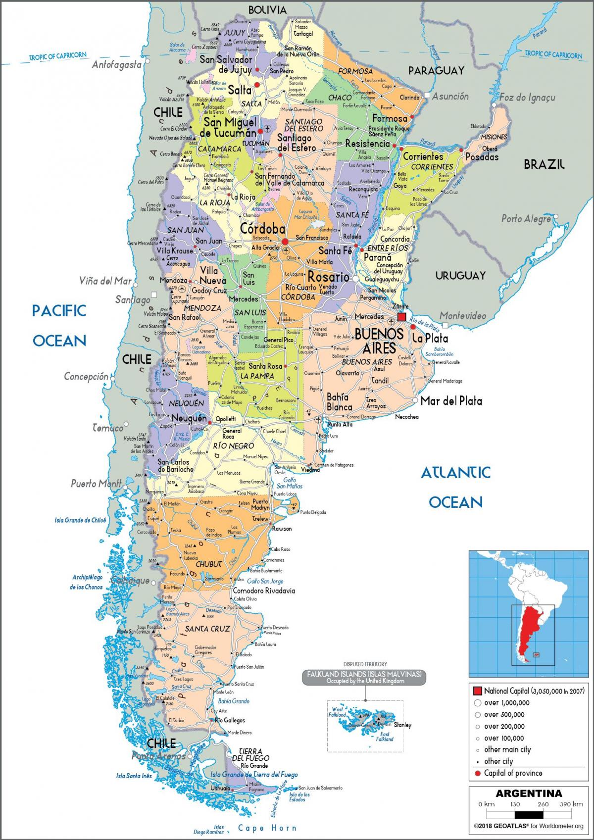
The Argentina states map shows all departments and regions of Argentina. States map of Argentina will allow you to know areas and cities of Argentina in Argentina. The Argentina states map is downloadable in PDF, printable and free.
The Argentine Republic comprises twenty-three states and the capital, Buenos Aires, which is an autonomous city as you can see in Argentina states map. Each of the states is divided into departments and municipalities, apart from Buenos Aires, which constitutes single administrative units called partidos. Partidos are the equivalent of departments in other Argentine states. Each state has its constitution which outlines the structure of its local government and directs how financial and natural resources at the provincial level are managed. Some states have unicameral parliaments while others have bicameral ones.
Argentina states as its shown in Argentina states map are: Buenos Aires, Catamarca, Chaco, Chubut, Cordoba, Corrientes, Entre Rios, Formosa, Jujuy, La Pampa, La Rioja, Mendoza, Misiones, Neuquen, Rio Negro, Salta, San Juan, San Luis, Santa Cruz, Santa Fe, Santiago del Estero, Tierra del Fuego - Antartida e Islas del Atlantico Sur (Tierra del Fuego - Antarctica and the South Atlantic Islands) and Tucuman. Ciudad Autonoma de Buenos Aires is an autonomous city of Argentina. These states are further subdivided into 378 departments and municipalities. The Buenos Aires state is subdivided into 135 partidos; while the autonomous city of Buenos Aires is subdivided into 15 communes.
Buenos Aires is an autonomous city and is the capital of Argentina, as well as the country most populous city. Cordoba is located in the central region of Argentina. Santa Fe is a province located in the central region of Argentina which occupies an area of 51,354 square miles and has a population of 3,481,514. Ciudad de Buenos Aires has a population of 3,068,043 and occupies an area of 78 square miles. It is one of Latin America most diverse cities due to the cultural, religious and ethnic diversity of its population. Mendoza is located in the Cuyo region of Western Argentina. The states in Argentina fall under the country seven major geographical regions as its mentioned in Argentina states map: Northwest, Mesopotamia, Gran Chaco, Sierras Pampeanas, Cuyo, Pampas, and Patagonia. Some provinces span more than one of these regions. These regions have distinct climates and topography which affect the economic, social, and cultural activities of the states.